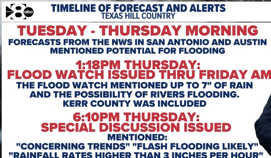
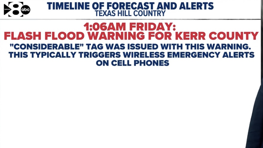
This wasn’t possible. They had watches in place the evening before, but it wouldn’t make sense to pull kids out of camps at that point. The warnings started at 1:00 am, and that’s when the camps and RV parks should have taken action. Some did, and others didn’t.
You seem to be looking at this like it was an approaching hurricane that has several days of advance warning. It wasn’t anything like that. They had more warning than a tornado, but way less than a hurricane.
Hindsight is 20/20 of course, but given this took place around the time of simultaneous storms, I would think maybe 1 adult would’ve attempted to raise concern prior to the main warning the night of
But I guess consensus suggests these floods were absolutely spontaneous and unexpected regardless of the activity in the area
Parents didn’t really have days to react, unless you think the NWS potential
statement was the key moment for parents and camp admins to start executing
their emergency plans. The WATCH assessment didn’t come until 1:18pm on Thursday afternoon. And the WARNING not until 1am the morning of the flash flood.
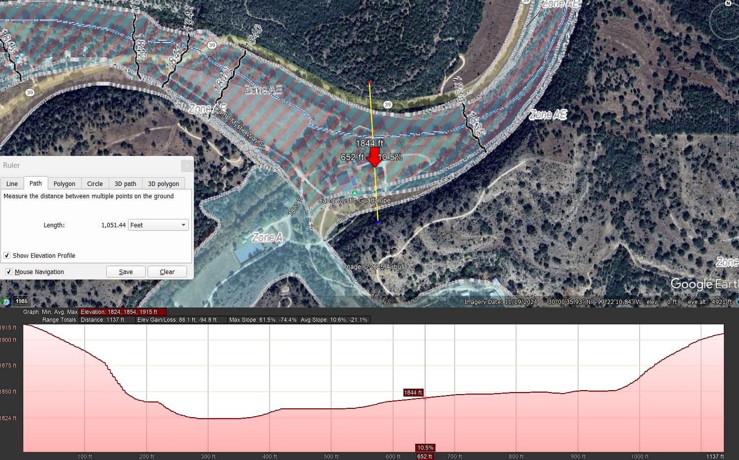
I’d like to know if these camps start to execute their emergency evacuation plans on a watch or a warning alert and how long they think it should take to execute their plans. I read a Mystic coordinator was trying to start evacs at 3am and water was already very high.
I feel like everything you say on this message board is spoken in code
I can hardly decipher about half of your arguments
maybe I’m just not intelligent enough
Duce630
(DustinK - Damn it feels good to be a Cougar. -Dwight Davis)
211
I feel like you do that a lot as well. Though it is very easy on message boards for the context to get lost amongst the posts, sometimes we could all be more clear.
If that’s accurate, it’s absolutely negligent. That warning around 1:00 am meant that flooding was imminent. Waiting for something more dire when you have a couple hundred kids literally sleeping on the river doesn’t make any sense.
Not defending the coordinator at all, but my assumption in that situation is that you’re deep down hoping for the absolute best (not expecting things to get dire)
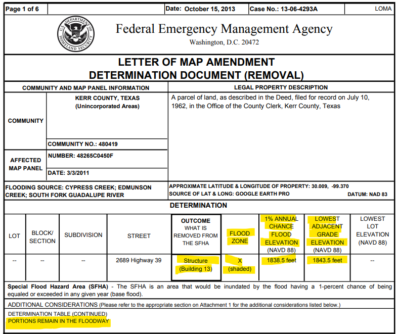
It shows that a structure (Bldg 13) was removed from the floodplain due to its elevation above the 100-yr floodplain elevation. The LOMA shows that the ground adjacent to the structure was 5’ above the 100-yr floodplain. It also says that the structure was revised to Zone X shaded, which means it was still considered to be in the 500-yr floodplain. Probably most importantly, is the note “PORTIONS REMAIN IN THE FLOODWAY”. The Floodway is the deepest and fastest part of the floodplain…the most destructive.
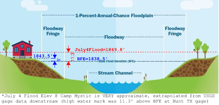
I made a quick graphic, using the elevations shown in the LOMA, and extrapolating the July 4 flood elevation from USGS gage data downstream. This is VERY approximate, but gives an idea of the elevations/depths we’re talking about. If my numbers are anywhere near correct, there would have been somewhere on the order of 6’ of high-velocity flood waters tearing through that cabin.
The problematic part, and probably the “lesson learned” here – the location of the cabins in the floodway. Hindsight is 20/20…and I don’t have the info to know what that structure is or when it was built. But generally it’s not a FEMA issue; they only create the maps and document revisions. The regulation of building permits in the floodplain is a LOCAL matter – Kerr County in this case. If this building was built before the initial floodplain maps, or before floodplain regulations were adopted locally, then Kerr County wouldn’t have had the opportunity to weigh in on it. At that point it’s the Owner’s risk…and the Owner may or may not have understood that risk. From what I’ve read, Dick Eastland was aware of flood risks and respected the power of the Guadalupe, but in this case, I think everyone underestimated the possibilities. Probably felt like these structures 20’ above the Guadalupe were “safe”. But this was a record flood in Hunt…never seen before. When it hasn’t been seen, most of us think tend to think it can’t happen. For Houston folks, our relevant comparison is TS Allison in 2001…and then Hurricane Harvey in 2017. Both were “once in a lifetime” events. I think we know enough now to say that there are even bigger storms lurking out there.
This is where we (humans) are so arrogant and short-sighted. How far back does the record-keeping go on the water levels at Hunt, Tx? Maybe 100 or 150 years? This flood was a known record by about 10 inches, so it was hardly inconceivable that a flood like this could happen.
I suspect that Eastland thought he had it under control until he realized this one was different, at which point it was obviously too late.
The successful appeals to have certain buildings removed from the FEMA floodplain tells me two things:
The owner really wanted to build more and save money on insurance
The owner clearly knew these buildings were in a “danger zone”
Flooding can certainly occur outside of FEMA’s 100 year flood plain. It happens whenever the circumstances are extraordinary such as what occurred in the Texas hill country last week. It is what it is.
[NOTE: There’s also a 500 year flood plain elevation which is less talked about.]
Sure they can. But a significant number of the people who died in this flood were INSIDE the 100 year flood plain (or right on the edge) and in clearly dangerous areas, especially given their ages and the total lack of a warning system. It didn’t have to be that way.
And these flood zones in river valleys that flash flood are far more dangerous than a 100 year flood plain in a Houston suburb. Frankly, it’s something of a miracle that anyone who went into those waters survived.
I just took a look at FEMA Flood Profiles for the area… 500yr BFE at Camp Mystic is approximately elevation 1,850’. Right at my “guesstimate” of the July 4 flood elevation.
FEMA’s 500yr Flood Elevation at the Hunt USGS Gage is 1,760’. The High Water Mark measured by USGS after July 4 is 1,760.3’ (37.5’ flood depth + 1,722.8’ elevation at bottom of gage).
That flood was right at the 500-yr elevation based on FEMA’s models. 500-yr storm is more accurately described as a 0.2% annual chance storm event. Low probability, but not zero.
Question everyone faces is, what is an acceptable risk? 1% annual chance? 0.2%? Do we design and build for even less frequent storms, like the 1000yr storm (0.1% annual chance)? The 100yr storm event is typically used as the design event in most places… is it enough?
Good stuff there, I appreciate the insight. I agree the failure was at the local (County) level for Camp Mystic. I hope they make meaningful changes to prevent this from happening again.
And I hope other communities across Texas and the US are looking at their own emergency action plans and notification systems. We’re seeing these catastrophic floods across the country at a pace I don’t recall hearing about in years past. I really do believe the warming climate contributes to the more intense rains and higher overall rainfall depths experienced across the country.